Heat in B.C. peaks, but wildfire danger and smoke rises with poor air quality
Thick wildfire smoke is blanketing parts of British Columbia, reducing visibility and air quality. To make complicate the situation, the looming risk of dry lightning could spark new blazes and worsen conditions in the province by Thursday
Lytton, B.C., tied an all-time Canadian temperature record for September on Tuesday during an unusual, late-summer heat wave.
A sizzling 40.0°C reading was recorded in the B.C. community amid an intense heat wave on the West Coast, sharing a national heat record with two other centres for the month of September.
DON'T MISS: When is the hottest stretch of the year in your corner of Canada?
The good news is that the heat peaked on Wednesday, but the bad news is there is an increased fire danger and resulting smoke as a result. To make matters worse, there could be dry lightning on Thursday and Friday as the dry conditions continue, and the wildfire smoke worsens and moves.
There are special air quality statements in place, warning of the potential health risks from poor air quality due to the wildfire smoke. Smoke haze will be present across the majority of the B.C. landscape and can be highly variable.
Heat, dry lightning with storm risk stokes wildfires; resulting smoke brings reduced air quality
A ridge of high pressure parked over British Columbia will reinforce, prolonging the unusually high heat many communities have experienced of late. Lytton, B.C., just saw a historic streak of four consecutive 40°C days and then recorded the national-tying record for September on Tuesday.
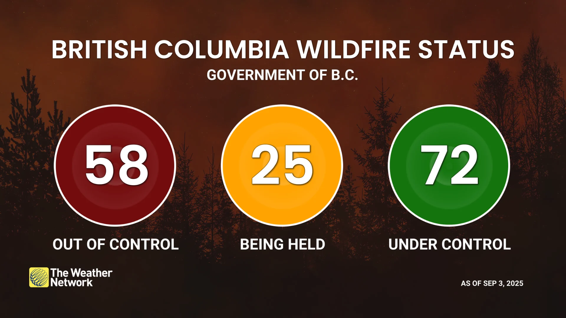
Because of the heat, we’re also on the lookout for rising fire danger. There are currently close to 60 out-of-control fires in B.C. as of Wednesday afternoon, up sharply from just a couple of weeks ago. More fires are possible amid this heightened danger.
On Wednesday, the smoke concentration from the wildfires led to it settling into the valley bottoms across the southwestern sections of the province.
Additionally, a low sitting over Washington state will contribute to instability over the B.C. coastline through Thursday, so there is still a risk of thunderstorms producing dry lightning.
The fire danger rating remains elevated along this area, from the Sunshine Coast to the Central Coast.

As a result, that could trigger more wildfires heading into and on Thursday.
From Wednesday overnight into Thursday morning, a cold front will sweep across the eastern portion of B.C. The resulting winds will shift to an offshore flow, originating from the northeast.
The shift of the winds directs the higher concentration of smoke towards the southwest.
Wildfire smoke can cause respiratory problems in those who suffer from chronic illnesses or respiratory diseases. If possible, stay indoors during periods of reduced air quality, and consider wearing a mask outdoors to reduce your exposure to fine particulate matter.

As smoke levels increase, health risks increase. Limit time outdoors. Consider reducing or rescheduling outdoor sports, activities and events.
The Interior will experience the heaviest smoke Thursday afternoon into the overnight hours while the Lower Mainland and Vancouver Island will experience the heaviest smoke headed through Friday.
Interestingly enough, the areas with the heaviest wildfire smoke will see a slight relief in the temperature.
Heavy smoke, blocking out the sun, can drop temperatures by 2-3 degrees, leading to slightly cooler temperatures but the values will remain above seasonal across the Interior.

Rain returns for the weekend
Dry through Friday, then scattered showers and thunderstorms on Saturday before more widespread precipitation and thunderstorms moving in on Sunday, and early next week.
Minimal rain is expected for the South Coast region, but locally heavy downpours are anticipated for the mountains.